Fig. 1
Archaeological site of Petra
This chapter discusses the interrelations between the issues listed in the previous paragraph and aims at proposing some possible guidelines derived from the activities carried out in the last years by our research group within the Department of History, Drawing and Restoration of Architecture of Sapienza—University of Rome. Together with a general methodological framing, we shall describe a number of research projects spanning from large sites (Petra—Fig. 1), single buildings/architectural structures (Temple of Divus Claudio, Rome—Fig. 2) and small objects (Tombs and artifacts in Crustumerium site, Rome—Fig. 3).
2 Survey, Modeling, Interpretation as Multidisciplinary Components of a Knowledge System
There can be no doubt that the first step in approaching the study of any archaeological element is constructing a Knowledge System that will enable us to collect, interpret and store information about it.
The components making up this system, however, are of various types: quantitative, first and foremost (essentially resulting from surveying operations), but also qualitative. While the former can and have to be channeled through a rigorous scientific approach, the latter draw on the investigator’s sensitivity and interpretative flair, that show themselves, at times even intuitively and extemporaneously, capable of attaining levels of understanding that are denied to simple “measurement”.
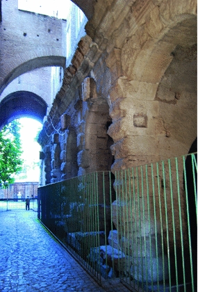
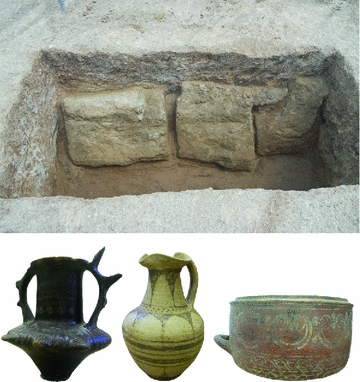
Fig. 2
The Temple of Divus Claudio, Rome
Fig. 3
Tombs and artifacts in the archaeological site of Crustumerium, Rome
In studies of archaeological elements (both on the large and the small scale), this process is particularly marked: not only is it necessary to construct a multidisciplinary database that is as consistent and rigorous as possible, but many different skills must be integrated in order to suggest interpretations that transcend the sectorial.
While the qualitative component lies in the reign of irrefutability (in the sense proposed by Popper), to the quantitative one belongs the Survey, one of the most powerful and reliable tools developed over the years by researchers (archaeologist, architects, historians, etc.) to achieve what Descartes used to define “profound knowledge”.1 It actually implies the idea of measurement, that is the possibility of turning into quantity some qualities of the studied phenomenon (in this case an artifact, a building, a site, etc.) by using the ratio between the measured quantity and an appropriate unit of measure.
Thanks to this method, that operationally implies the measurements of a certain number of points, we build a simplified model of the complex phenomenon we are investigating. Quite apart from the theoretical framework, it’s paramount how in practical terms the implementation of this strategy depends on the available measurement technologies. As for centuries the limited amount of measurable points implied a preliminary attentive design of the survey operations in order to capture the really significant ones (selection before acquisition), in the last decades this order has been somehow turned upside down thanks to new massive measurement technologies in which selection often follows acquisition [4, 5].
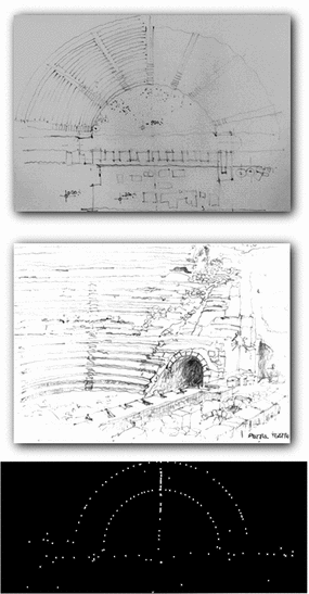
Fig. 4
Selection of data: form perception to measurement
Let’s try then to clarify this fundamental point, firstly from a linguistic point of view: the term Survey refers in fact to a very structured process that leads to the construction of 2D or 3D models starting from a real object. The whole workflow can be broken-down into several different tasks of which, certainly, the acquisition of data (surveying) represents the first step. All following tasks (in the survey process) dealing with selection, interpretation and representation of acquired data actually lead to models (3D, 2D-drawings, etc.) that somehow concur in enlightening the investigated phenomenon. The traditional survey approach implied (and obviously still implies) a strict dependence of the surveying phase on a preliminary deep investigation able to guide the limited measurement possibilities (Fig. 4).
This intrinsic limit obliges somehow to an as accurate as possible design of the surveying operations in which selection, interpretation and representation of data come even before the measurement, as if the survey existed in the surveyor mind before the physical set up of the operations and expected somehow only a verification. The Survey’s workflow is in this framework potentially defined right from the start.
Massive acquisition technologies have actually separated all different steps: site preliminary study is only oriented to the position and number of stations (scans, shots, etc.) while the topographic support is reduced to the minimum when even no more necessary in the surveying phase. Selection, interpretation, and representation of data are instead carried out in a second phase.
Together, these considerations thus establish the horizon of research, putting the Survey process in the more general framework of a Knowledge System as the non-additive result of single sectorial contributions, where there is a clear boundary between the procedures for acquiring and organizing data (which strive for the maximum objectivity) and the criteria for selecting and processing the database itself (critical expressions invariably subjective).
3 Towards a “Scientific” Surveying
It is precisely by establishing this boundary, this demarcation, that we can view the entire question in the light of the Scientific Method consolidated among the various communities of researchers, putting it to the test of Karl Popper’s “principle of falsifiability”, still the benchmark for evaluating scientific theories.2
The Surveying phase, in fact, seems to be highly compatible with the strict scientific methodological assessment that is commonly utilized by other research areas (physics, biology, etc.) [4, 5, 13].
It’s unfortunately impossible in this occasion to provide an exhaustive discussion concerning the Scientific Method adopted by the general scientific community. Nevertheless we cannot proceed without listing at least the crucial points of this Method: currently considered scientific is (1) the investigation of a phenomenon developed using a set of techniques; (2) based on the gathering of observable, empiric and measureable data affected by a controlled and declared level of uncertainty; (3) those data will have to be archived, shared and independently assessed; (4) all used procedures have to be replicable in order to eventually acquire a comparable set of data.
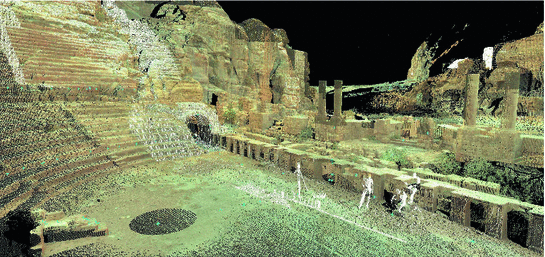
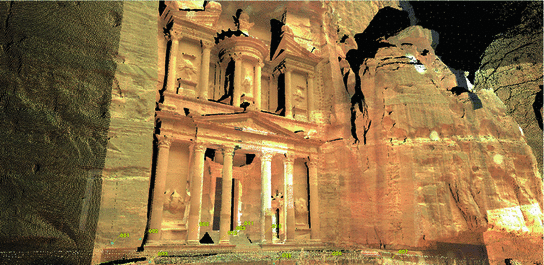
Fig. 5
Archaeological site of Petra—the data acquired using scanning techniques
Fig. 6
Archaeological site of Petra—the observable, empiric data acquired on site
Fig. 7
Archaeological site of Petra—the measurable data acquired on site
These four main points can be substantially respected during the Acquisition phase:
1.
The investigation of the phenomenon has to be developed using a set of techniques (Fig. 5)—Being the “phenomenon” in our case the object to be surveyed, this prescription is clearly respected because any survey uses methods and techniques able to guide the surveyor during the measurement phase. As already discussed, only metric information complies with this criterion being instead excluded all that, perceived or even intuited by the surveyor, cannot be codified in quantitative terms thanks to measure operations.
2.
Based on the gathering of observable, empiric and measurable data affected by a controlled and declared level of uncertainty (Figs. 6 and 7)—All data are actually observable (they represent the “material” points of the object), empiric (they result from experimental activities), measurable (they are acquired using measure equipment and techniques) and affected by a controlled and declared level of uncertainty (resulting from the instruments, the systematic errors, etc.). The actual compliance with this prescription can be assured provided that all steps (from the survey project to the measurement and assessment process) are documented with accuracy and attached to the data themselves, so to create a unique set composed by data (the measures) and metadata (the process information). Unfortunately this procedure is too seldom adopted in the survey activities.
3.
Data will have to be archived, shared and independently assessed—The so-called “digital revolution” has affected this aspect very deeply. In the specific field of architectural Survey it wasn’t at all a consolidated habit to arrange and archive systematically both the final deliverables and the metadata describing the procedure used during the experiment called “survey” (survey project, field notebook, measured points monograph, instrumental features, etc.). The quick and sudden switch to new equipment for massive point acquisition (3D scanning, photomodeling, etc.) has actually mitigated a lot this problem as many metadata are already archived in a database form by the instruments themselves. Furthermore, archives are “born digital” with clear advantages in terms of transmission, sharing and duplicability, features that in the recent past were impossible being each archive a single, original set of data. The sharing and independent assessment seems to be a more critical aspect: differently from other research areas that show more consolidated traditions in immediately online sharing of experimental data, the archaeological (and in general the cultural heritage) sector is still too affected by high confidentiality levels. We should thus all work to catch up with other research areas so that the archived data could more easily circulate within our scientific community and any researcher could develop its activity on high quality data. In this framework some attempts are being carried out but much work has still to be done.3
4.
All used procedures have to be replicable in order to eventually acquire a comparable set of data—This last point actually comes up as a sort of corollary form the previous three. Nevertheless, it can produce very significant effects involving the definition of procedures suitable in “diachronically” integrating data acquired in different time segments and with different technologies. In this way all information connected with a certain object would find a compatible space in a single database that, in case of new investigations, would not start from scratch but simply be updated and improved with the new surveyed data.
4 From Acquisition to Selection and Interpretation of Data: From Surveying to the Models
Selection and interpretation complete the proposed path for Survey. It has been already widely discussed how both phases concur not secondarily to the construction of the geometric model of the surveyed object, that is to that reduction process of the objective multi-dimensional complexity to its geometric essence made of points, lines, surfaces. A biunique correspondence is set in this way between the object and its virtual substitute which can be used to simulate different operations as they were made directly on the object itself.
From a strictly epistemological point of view such a model can be considered the result of a selection operation carried on by a subject on an object aiming at extracting some of the potentially infinite available information. The selected data, though, are not the result of a random or automatic reading: on the contrary they strictly comply with rules set, even if with different level of consciousness, in advance by the subject himself. In this way a stable relationship real object/model is crated: a relationship that intrinsically already represents an interpretation of the selected data. In other words, starting from the selected set of data, we always tend to demonstrate an hypothesis we have beforehand formulated.
This particular process has been traditionally rooted in the following principles:
This procedure establishes a biunique correspondence between the Object and its Graphical Representation which can more appropriately be considered a Two-Dimensional Graphical Model, or in other words a virtual substitute on which the most widely varied operations can be simulated as if they were actually performed in reality.4
Human beings have an ability, innate or acquired, to conceive the qualities of physical space.
Of the n qualities of physical space, the geometrical qualities optimize the operations of control and manipulation.
Space can be concretely manipulated and modified thanks to the correspondence between the real object and its geometric abstraction (Geometric Model).
The Geometric Model, through the process of Representation becomes a Two Dimensional Geometric Model.
The tool that ensures that the mechanisms for controlling and manipulating the graphic model are effective is Drawing.
Since digital media burst on the scene and modeling software came into common use, however, this scheme has changed in a number of significant ways. First, the correspondence between physical space and representation has become practically perfect in the case of the latter development (Fig. 8): each material point  identified by its coordinates
  in real space corresponds immediately to a virtual point
  , likewise identified by a unique set of three Cartesian coordinates
  , essentially freeing itself from any and all constraints associated with the size of the support or with projection and sectioning.
identified by its coordinates in real space corresponds immediately to a virtual point , likewise identified by a unique set of three Cartesian coordinates , essentially freeing itself from any and all constraints associated with the size of the support or with projection and sectioning.The computer screen becomes the de facto interface between these two parallel universes, a window from which we can look out onto the space of these truly three-dimensional models. Nevertheless, it is also the definite limit of our exploration that keeps us firmly and forever on this side of the glass, so that the only opportunities for interaction with the virtual space are provided by the tools that enable us to explore, model and manipulate virtual entities.
Related posts:
Stay updated, free articles. Join our Telegram channel

Full access? Get Clinical Tree