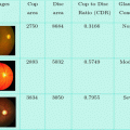
Fig. 3.1
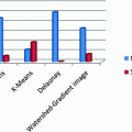
Delaunay method representation
TRI = delaunay(x,y) for the data points defined by vectors x and y, returns a set of triangles such that no data points are contained in any triangle’s circumscribed circle. Each row of the m-by-3 matrix TRI defines one such triangle and contains indices into x and y. If the original data points are collinear or x is empty, the triangles cannot be computed and delaunay returns an empty matrix [8].
Delaunay uses Qhull.
TRI = Delaunay (x,y, options) specifies a cell array of strings options to be used in Qhull via Delaunay. The default options are {‘Qt’,‘Qbb’,‘Qc’} [8].
This method derives spatial relations between the detected image objects and also performs pixel grouping.
3.3.1 Watershed Segmentation
A well-known image segmentation technique is morphological watershed transform, which is based on mathematical morphology to divide an image due to discontinuities. The concept of watersheds is based on visualizing an image in three dimensions: two spatial co-ordinates versus intensity. In such a “topographic” interpretation, we consider three types of points: (a) points belonging to regional minimum; (b) points at which a drop of water, if placed at the location of any of those points, would fall with certainly to a single minimum; and (c) points at which water would be equally likely to fall to more than one such minimum. For a particular regional minimum, the set of points satisfying condition (b) is called catchment basin or watershed of that minimum. The points satisfying condition (c) form crest lines on the topographic surface and are termed divide lines or watershed lines [6] (Fig. 3.2).
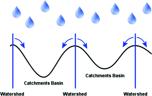
Fig. 3.2
Watershed representation
The principle objective of segmentation algorithms based on these concepts is to find watershed lines. The basic idea is simple, suppose that a hole is punched in each regional minimum and that the entire topography is flooded from below by letting water rise through the holes at uniform rate [9]. When the rising water in distinct catchment basins is about to merge, a dam is built to prevent the merging. The flooding will eventually reach a stage when only the tops of the dams are visible above the waterline. These dam boundaries correspond to the divide lines of the watersheds. Therefore, they are the (connected) boundaries extracted by a watershed algorithm. In contrast to classical area based segmentation, the watershed transform is executed on the gradient image. A digital watershed is defined as a small region that cannot assigned unique to an influence zones of a local minima in the gradient image. Also these methods were successful in segmenting certain classes of images; due to the image noise and the discrete character of digital image, they require significant interactive user guidance of accurate prior knowledge on the image structure, and easy to be over segmentation and lack of smoothness.
Watershed algorithm:
Let M1, M2, M3 … Mn be the sets of coordinates of points in the regional minima of the image g(x,y)
C(Mi) be the coordinates of points of the catchment basin associated with regional minima Mi
T[n] = {(s,t) | g(s,t) < n }
T[n] = Set of points in g(x,y) which are lying below the plane g(x,y) = n
n = Stage of flooding, varies from min + 1 to max + 1
min = minimum gray level value
max = maximum gray level value
Let Cn(M1) be the set of points in the catchment basin associated with M1 that are flooded at stage n.
![$$ C_{n} (M_{i} ) = C\left( {M_{i} } \right) \cap T[n] $$](/wp-content/uploads/2016/11/A338562_1_En_3_Chapter_Equa.gif)
Cn(Mi) = 1 at location (x,y) if (x,y) Є C(Mi)
AND (x,y) Є T[n], otherwise it is 0.
C[n] be the union of flooded catchment basin portions at the stage n

![$$ C\left[ {\hbox{max} + 1} \right] = \mathop \cup \limits_{i = 1}^{R} C\left( {M_{i} } \right) $$](/wp-content/uploads/2016/11/A338562_1_En_3_Chapter_Equc.gif)
Algorithm keeps on increasing the level of flooding, and during the process Cn(Mi) and T[n] either increase or remain constant.
Algorithm initializes C[min + 1] = T[min + 1], and then proceeds recursively assuming that at step n C[n − 1] has been constructed.
Let Q be set of connected components in T[n].Related posts:

Stay updated, free articles. Join our Telegram channel

Full access? Get Clinical Tree